

Satellite images purporting to show Cambodian incursions onto Thai territory are incorrect and misleading, according to the Ministry of National Defence. The images, widely shared by Thai media, feature unilaterally drawn border lines which are based on colonial-era border markers which have not all been ratified by both sides.
The images have been used as official references for the Thai military and Sa Kaeo provincial administration as justification for punitive action against the villagers of Chouk Chey and Prey Chan villages in Banteay Meanchey provinces’ O Beichoan commune, in O’Chrouv district. The Thai authorities have claimed that the villages are on Thai territory, and have threatened to prosecute villagers who protest against the action of Thai authorities, or evict them from the homes where they have dwelt for decades.
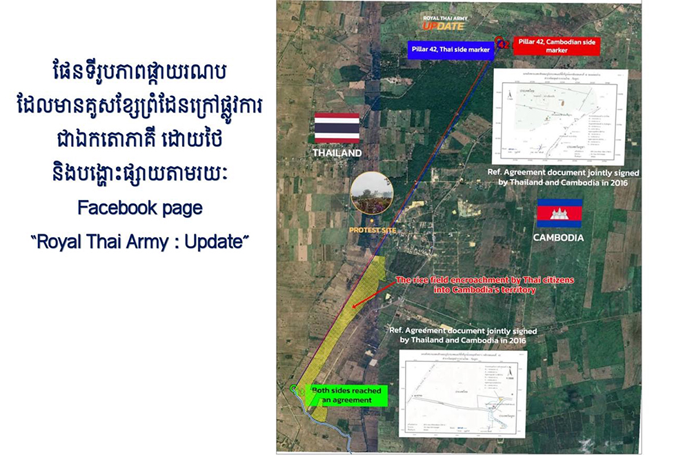
Somewhat ironically, the doctored maps also show Thai farms and infrastructure inside Cambodian land, added the ministry.
Irregularities in Chouk Chey images
Chheng Khun, deputy director of the defence ministry’s Department of Geography, explained on September 24 that the Thai satellite images which showed the location of boundary markers in the Chouk Chey area were intended to distort the facts, misleading the domestic and international public into believing that Cambodian citizens had encroached on Thai territory.
He noted that a working group had conducted on-the-ground investigations determined that the border line between boundary markers 44 and 47 was inaccurate and misleading.
“The red and blue lines shown on the Thai satellite image map are not official, mutually agreed-upon boundary lines. They are simply connecting lines drawn unilaterally by the Thai side outside of the official process, used to mislead the public and suggest that Cambodia has recognised them,” he said, referring to the satellite images posted by The Royal Thai Army Update Facebook page.
He explained that while the images bear the signatures of Lay Siengly, former Chief of the Cambodian Survey Team, and General Chakorn Boonphakdee, former Chief of the Thai Survey Team, the maps only confirm the position of the French colonial period boundary markers, not the border itself.
“They are not maps or documents which define or confirm the boundary line. The claim that Siengly’s signature constitutes official recognition of the boundary line is not true,” Khun said.
He added that the team which investigated the terrain identified the occupation of Cambodian territory by Thai citizens, as well as the construction of a Thai road.
“I must stress that in the past, the Thai military and provincial authorities have selectively used unilateral maps to make claims, showing only areas where they allege Cambodians encroached into Thai territory, while omitting areas where Thai citizens and soldiers have themselves encroached into Cambodian territory,” he said.
The case of Prey Chan
A similar explanation could be applied to Prey Chan village, where Thai authorities have once again used a unilaterally drawn map to claim Cambodian encroachment. Much like in Chouk Chey, the images also reveal that some parts of the Cambodian village are occupied and used by Thai citizens.
The Thai military and Sa Kaeo provincial administration have used the map to claim territory in the disputed area, installing razor wire barricades and threatening Cambodian villagers with eviction.
According to Khun, even if one were to rely on the unofficial lines drawn on the satellite image between border markers 42 and 43, the reality on the ground would show that Thai citizens are occupying Cambodian territory.
Khun noted that this information has not been previously revealed to the public by Cambodian authorities, as Cambodia respects the principle of confidentiality that were set by the Joint Boundary Commission (JBC).
He added that Thailand has not respected this principle by presenting their unilateral maps to the domestic and international public.